Where's our accessible countryside?
Natural England recommends that everyone, wherever they live, should have
- An accessible natural green space: (ANGS) of at least 2 hectares in size, no more than 300 metres (5 minutes walk) from home.
- At least one accessible 20 hectare site within two kilometres of home.
- One accessible 100 hectare site within five kilometres of home.
Saffron Walden is said to be one of the best places in England to live, despite rapidly disappearing under unaffordable housing, and you'll find very little countryside you can explore other than along a public footpath or bridleway. It is a long way from the recommended area of accessible countryside
Let's take Sewards End (home of our open access Noakes Grove) and ask where is there any other open access natural countryside? Noakes Grove (about 3.5 ha) is about 600 m from the village hall along Redgates Lane. That's the only area of access countryside in the village but Little Hales Wood(18 ha) is some 2 km away in Ashdon and Bendysh Woods (90 ha) are about 5 km away in Radwinter. So, all in all, Sewards End is not far below the Natural England recommendations but only because Walden Countryside, in 2009, opened their Noakes Grove nature reserve. All Essexdistrict coumcils have created country parks and local nature reserves for its residents. Only Uttlesford had neither kind of council provided access countryside.
Several hundred bits of countryside in Essex are designated as Local Wildlife Sites (LoWS) by Essex County Council. Designation is done whether or not the site is "private - no entry" or one where the public are free to explore. The theory is that the District Council must consider a LoWS's value before giving permission for damaging development. In theory, LoWS owners are supposed to be contacted to discuss possible improvements to their site's management. This used to be a role of the Essex Wildlife Trust but they have withdrawn from any involvement with LoWS preservation. Walden Countryside has owned Noakes Grove for 16 years and never had a visit or other contact from ECC or EWT regarding the site. They did not even ask permission for their ecologist to resurvey the site. On the plus side, they did extend the area designated as a LoWS to cover the whole of Noakes Grove.
Here's a map of Sewards End with the LoWS marked as are the public footpaths and bridleways. Noakes Grove is the only natural public access land actually in the village./
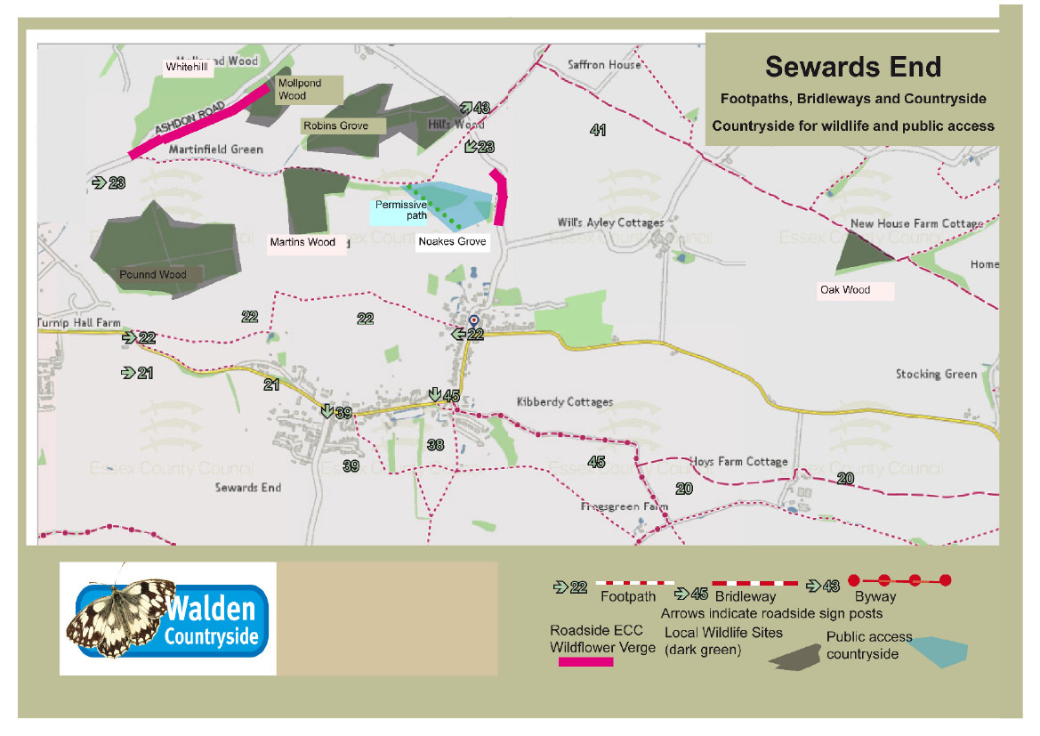
The map shows (in dark green) the five blocks of ancient woodland which are designated as LoWS - all five are privately owned and none have any public access, not even on public paths.
There are over 150 LoWS in the 27 parishes that make up the Walden Countryside. Most have no access and the owners are not known. You can see full details (and a map) for all thosein your parish by clicking
https://walden-countryside.co.uk/LoWS-in-Walden-Countryside.html
If you are the owner of a local wildlife site we would love to make contact with you. If you know who is the owner of a site in your parish we would also value that information. We might be able to offer the owner some advice on possible grant aid for wildlife friendly management and/or permitting public access.
The map also shows two length of roadside verge which have a special type of LoWS designation and which ECC says it protects by getting its contractors to cut the verge at a time which favours the survival of its special wild flowers. The Ashdon Road verge has an important colony of crested cow-wheat but it is dangerous to walk beside of the verge because there is no footpath and lots of speeding traffic. The marked verge in Redgates Lane once had crested cow-wheat and wild liquorice but lack of suitable management created too much shade and the plants died out. This verge has now been removed from LoWS designation by ECC.
Sewards End has nine public rights of ways - 5 footpaths, 3 bridleways and 1 byway) totalling almost six km. Old maps show a path connecting fp 23 to Wrens Farm. This is no longer a public footpath but we have created a permissive path along about half the lost path route. It connects fp 23 to Noakes Grove.
|